Captain George Vancouver's 1792 to 1794 Surveys of the Pacific Coast

Captain George Vancouver’s Pacific Coast Survey
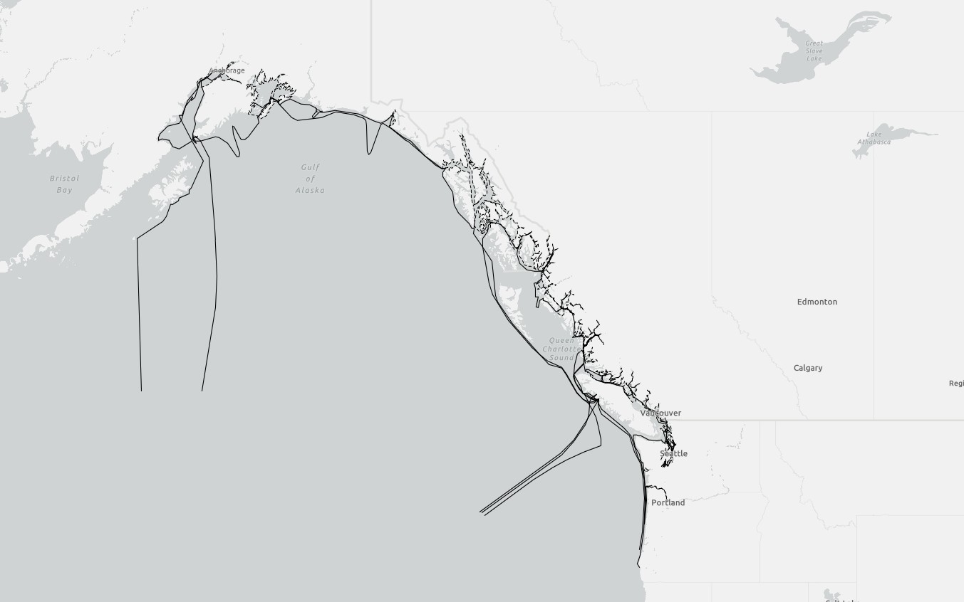
Captain George Vancouver’s 1792-1794 coastal surveys along the Pacific Coast of north western North America would be accomplished in some of the severest marine conditions. Captain Vancouver died in 1798, and it would be over a hundred years later that Vancouver and his crew’s incredible nautical accomplishments would finally be recognized. There can be no doubt that Vancouver’s expedition is perhaps one of the great maritime surveys of the 18th century. Like Captain James Cook before him, Vancouver would ultimately conclude that the famous Strait of Anion or the Northwest Passage did not exist.
A spatial dataset was created to record the known movements of HMS Discovery and HMS Chatham and their respective survey boats between 1792 and 1794. The linear data was created to encompassed Vancouver’s coastal survey and were researched from Vancouver’s published journals and other numerous records. The linear data contains the fields that includes Ship, Vessel, Crew, Arrived, Departed, Year, Route, Leg, and Notes.
The resulting measurements of the data are as follows: The distance calculated for HMS Discovery and Chatham during the 1792 survey equates to approximately 3,404 km and the distance travelled by the survey boats equates to approximately 5,859 km . The distance calculated for HMS Discovery and Chatham during the 1793 survey equates to approximately 5,414 km and the distance travelled by the survey boats equates to approximately 6,152 km . The distance calculated for HMS Discovery and Chatham during the 1794 survey equates to approximately 4,327 km and the distance travelled by the survey boats equates to approximately 5,468 km .
Captain Vancouver died of a lengthy illness at just 40 years of age in 1798 and it would be over a hundred years later that Vancouver and his crew’s incredible nautical accomplishments would finally be recognized. There can be no doubt that Vancouver’s expedition is perhaps one of the great maritime surveys of the 18th century.
The explorations carried out by HMS Discovery and HMS Chatham were researched from Vancouver’s published journal and other records. From the completed research, spatial data was created and is organized into the fields Year, Route, Leg, Departed, Arrived, Origin, and Destination.
The data is in ESRI shapefile format and can be acquired HERE.
A Map (26 x 30 inches at 300 dpi) that details Vancouver’s 1792 surveys along the coast of Washington State and British Columbia and is suitable for printing or study can be acquired HERE.
A Map (27 x 35 inches at 300 dpi) that details Vancouver’s 1793 surveys along the coast of British Columbia and Alaska and is suitable for printing or study can be acquired HERE.
Captain George Vancouver’s 1792 to 1794 Costal Surveys of the Pacific Coast